Maryland has one of the most unusual shapes of all the states. It started as a straightforward land-granting charter from King Charles of England to Cecilius Calvert, but then it saw repeated changes as realities unknown from across the ocean came into focus. Exploration, science, error, courts and plenty of politics all played roles in defining each line and corner of the state. The history of how Maryland took its physical shape turns out to be as interesting as any other piece of the great state’s lore.

The King’s charter for Maryland outlined the boundaries of the future state and much more. It covered mineral and fishing rights, governance, taxation, safety, security, and colony administration. Notably, the first paragraph (alongside an unfortunate passing mention of “savages”) said that the charter was for “uncultivated” country. As it turned out, this word would literally shaped Maryland when others interpreted the boundary description, which is summarized for clarity as:
"between the Ocean and the Bay of Chesapeake, divided by a Right Line from Watkin’s Point unto the main Ocean on the East; and between that Boundary on the South, unto the Fortieth Degree of North Latitude; passing from the Delaware Bay in a right Line unto the true meridian of the first Fountain of the River of Pattowmack, thence South, unto the further Bank of the said River, and following the same, unto near the mouth of the said River, and thence by the shortest Line unto the aforesaid Watkin's Point."
The 1632 description was sound enough, needing only to determine the locations of both Watkins Point and the Potomac headwater. Otherwise it was the ocean and Delaware Bay on the East, the 40th latitude on the North, a line due-north from the Potomac headwater on the West, and the south shore of the Potomac River would close the circuit. But as it turned out, settling the two unknowns and many other factors would take centuries.
The charter starts on the South. The East-West “right line” from Watkin’s Point to the Ocean was intended to divide the Maryland and Virginia eastern shores. The location of Watkins Point was generally known among the inlets, tributaries, and tidal islands but it was still argued over. Today’s border line was unfortunately tilted due to uncorrected magnetic compass variation, and it was also adjusted over the years to share crab and oyster habitats between the states. Interpreted differently, a few dozen square miles around New Church, VA, may be Maryland today.

The Southern border and Western border of Maryland were intertwined by the location of the Potomac River headwater, or first fountain. A 1746 expedition said it was at the head of the North Branch of the Potomac River. Although other tributaries are decidedly smaller, it could be debated, and is dependent on rainfall, if the North Branch or South Branch is actually larger. The expedition declared the North Branch larger and, over Maryland’s protest, that headwater was officially marked by “The Fairfax Stone.” The Western border became a line due north from the headwater to the 40th latitude and the southern border followed the bank of the river to the bay. Had the South Branch been used, the headwater would have been placed 55 miles south and 5 miles west, adding about 1800 square miles to Maryland that is now West Virginia and Virginia. In the map below, the red lines show the current state (using the North Branch) and the blue lines show the alternative using the South Branch.


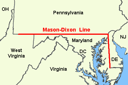
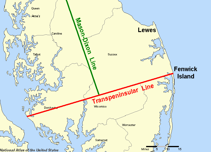
The Eastern boarder is where the word “uncultivated” came into play. Most of today’s Delaware was settled (cultivated) early by Swedes and Dutch, so the 1682 Pennsylvania charter reassigned this area from Maryland to Pennsylvania. A subsequent 1685 agreement then declared that a straight line would divide the peninsula vertically in two, with an East-West line drawn at “Cape Hinlopen.” Once again the language appeared straightforward, except at the time there was both a Cape Inlopen (at the current day Cape Henlopen) and, 25 miles south, there was a Cape Hinlopen (at the current day Fenwick Island). Pennsylvania interpreted the confusion favorably for themselves and Maryland realize too late that they had given away a tract of 800+ square miles of land. The East-West “Transpeninsular Line" was surveyed and placed in 1751 while the vertical line was left for another group.

Maryland’s Northern border is its most famous. The charter clearly cites the 40th latitude, but it turns out that line bisects Philadelphia. A negotiated agreement was once again needed. The line dividing Delaware and Maryland, 12 miles West of New Castle, could simply have continued due north to exclude Philladelphia, but instead the entire border was moved 19 miles south - 15 miles south of Philadelphia to be exact. It was from here that two surveyors set out to establish what we now know as the Mason-Dixon line. By 1767 they concluded their survey of the border between Maryland and Pennsylvania, as well as the border between Maryland and Delaware down to the Transpenisular Line. About 3900 square miles (of Maryland) above the Mason-Dixon line, and below the 40th parallel, officially became Pennsylvania.
This perimeter review concludes with one final change to Maryland’s shape. The 1790 Residence Act established a Federal Capital for the United States to be located on the Potomac River. A 10 mile by 10 mile diamond-shaped district would straddle the river with both Maryland and Virginia ceding land for the purpose. However, by 1847 Virginia had regained their land by retrocession, meaning all 68 square miles of today’s federal capital, the city of Washington, District of Columbia, is land that once formally belonged to Maryland. It was a small contribution to a worthy cause.

The aggregate loss of land by Maryland by these many cuts is not insignificant. At 12,406 square miles total, Maryland is just the 42nd largest state so every little bit counts. Not that every little bit lost represents a legitimate grievance, but it is interesting to tally the total. In all, Maryland could have been about 6600 square miles (53%) larger if the 40th latitude, South Branch headwater, and today’s Cape Henlopen had been used. (Shown in blue in the map below.) Including the areas excluded as “cultivated areas, the rest of Delaware and area around Philadelphia below the 40th latitude, would have added another 2000 square miles. (Shown in orange in the map below.) Maryland would still be shy of overtaking West Virginia for 41st place, but it would look very different from today.


Map showing the areas of Maryland's chartered land lost to for various reasons: exploration (Potomac headwater), interpretation (cultivated Delaware), negotiations (the Mason-Dixon), and secession (to establish Washington, D.C.).
With or without the lost land, Maryland’s shape was bound to be interesting. The combination of using both rivers and latitudes, natural and artificial demarcations, made that inevitable. Those writing the charter could not have known how far north the Potomac River went. In fact, when Mason and Dixon were surveying, they were concerned that the revised border, 19 miles below the 40th latitude, might actually intersect the river and cut Maryland into two discontinuous parts. As it happened, they had under two miles to spare. A narrow stretch of land at Hancock keeps the Maryland in one shape - one funny looking shape.
Maryland is two miles wide at its narrowest and 256 miles long from northwest to southeast corner. Her borders are a meandering river on the south, an ocean on the east, and a surveyor's straight line for the rest. A latitude was lowered for William Penn, three “cultivated” counties became Delaware and a diamond-shaped district became our nation’s capital. Maryland could rightly dwell on land lost for many reasons, but it has too much to be proud of as it is. It is a state so rich in history, even its unique shape tells a story. A story of land-grants written from afar, of exploring parts unknown, of politics at play, of science and errors, and of compromise. It is a great story to remember each time one looks at this great state’s shape. ~
