The Maryland Challenge
- Joe McPherson
- Nov 18, 2021
- 7 min read
Updated: Jan 11, 2022
I first heard about the Maryland Challenge while looking for a tough day-hike near Washington D.C. I knew the Appalachian Trail passed through Maryland having hiked parts of it over my life. Searching for information on it lead me to this Washington Post article about two friends completing all 41 miles in one day. Doing this is called the Maryland Challenge by Appalachian Trail through-hikers (because through hiking is not enough of a challenge I suppose!). After reading the article, I knew it was just a matter of finding a friend fit and crazy enough to do it with me. As it turned out, I have two and I needed them both.
I began with some basic armchair research. Hiking Upward had the most straight forward information on Hiking the Maryland Challenge, along with reviews from others who attempt it. The maps and descriptions were a great starting point and I took seriously the tips from others about packing lite, and also packing a light. The plan was to start at the Mason-Dixon line and hike south to Harpers Ferry. To capture all the information in one place, I decided to create my own map with mile markers, elevations, and a timetable to keep us on schedule.


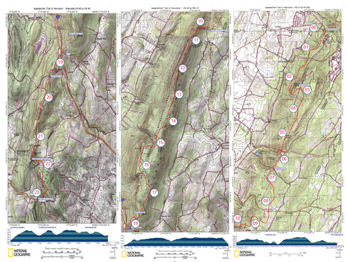
Another piece of advice from others was to go on one of the longest days of the year in late-June. 40.7 miles of hiking needs about 17 hours at a 2.5 MPH pace. According to Time and Date (Hagerstown), late-June sunrise was at ~5:40AM, so we could plan to start hiking closer to 5AM with first twilight. This would allow us to descend the Weaverton Cliffs toward the end of day while there was still some sunset light. The final 2+ mile walk on the C&O towpath could be done safely in the dark with headlamps, or even without them with some moon illumination.
Fortunately, the year I wanted to hike I got to know my friend Russ who, in his words, “does this (hiking) for a living" in the Army. Russ married my Coast Guard Academy classmate, Lisa, and if in bear country or on long hikes you want to be the fitter one, I was screwed. But if you wanted someone who knew what they were doing, I was lucky. Russ and I bivouacked out on the Mason Dixon line the night before, barely sleeping, and started our walk just after 5AM as planned.
I'll spoil it right here by saying I only made it about 31 miles with Russ before I had to throw in the towel. It was great to hike with someone experienced. He kept a comfortable pace, reminded me to drink more water and to add salt to lunch to make up for salt lost to sweat. Unfortunately, it turned out my stomach did not like the MREs we ate and my mental stamina was at a life-time low for other reasons. I felt bad bailing on him but he soldiered on and finished alone while I committed to finishing it next time; next year.
Like I said, I was fortunate to have two friends who could attempt the Maryland Challenge with me. With June coming around again, and Russ off doing Army stuff, I asked my friend John if he was interested. John once ignored the advice of an online marathon preparation site that said "you do not have enough time to train" before finishing a marathon a few weeks later. He thought the Maryland Challenge was some sort of fundraiser and, when I explained it was simply a random, painful, day of hiking for no real reason, it oddly made him more interested. John was in and I updated the plan to avoid last year's pitfalls.
First, knowing my Dad, a fan of Maryland and nature, would not hesitate to be part of the adventure, I asked him to be our driver. He jumped at the chance. He would drop us off, pick us up, and meet us with lunch at the half-way point so we could pack just water and snacks. Speaking of lunch, MREs were off the menu so I asked my wife Giulia if she would make a large baked pasta dish. (Before you judge: asking an Italian to make pasta is more of a compliment than a request.) Finally, for timing, we decide to just drive up at 3AM instead of getting a fitful night sleep on the ground. We had a plan.

John met my Dad and I at the house at 3AM. We each had a few bagels and some coffee while Dad drove us up toward the Pennsylvania border. We'd started hydrating the day before and carried 3L packs plus a bottle and snacks. We met the trail at the Mason-Dixon line just after 5AM and, after a quick picture, we set out just ahead of the rosy-fingered dawn (mile 0, 5:10AM).

The first section followed a rail line past Pen-Mar park before a tough and rocky first climb up to High Rock (mile 3.1, 6:26 AM). After a quick descent to cross Route 491 we ascended again and proceeded to the Ensign Cowell shelter (mile 9.1, 9:05AM) where we topped off our water from a spring. (For the curious, we packed life-straws.) We noticed a lot of Sassafras's trees along the trail and were grateful for the nearly perfect weather; clear and warming, but not hot.

Following another quick ascent after crossing Route 17, we found ourselves on the second section. Here the trail followed a long ridge past Black Rock Cliff (mile 15.3, 11:27AM) and Annapolis Rocks. This section was full of day hikers in flip-flops and Pileated Woodpecker calls which entertained us until we descended to cross I-70 on the footbridge (mile 18.6, 12:39PM). After the highway was just a moderate ascent, but we both felt gassed. Fortunately, a tray of baked pasta was just ahead.

My dad met us at the George Washington State Park (mile 21.6, 2:01PM). He'd spent the morning exploring the area's historical landmarks but lit-up when we came into view. He always loved Maryland and hiking and adventures so being part of this Maryland-hiking-adventure thrilled him, even in a supporting role as his age and health dictated. We devoured our lunch, refilled our water at a spigot and set out for the second half of our day as Dad went off to explore some more of Maryland.

The third section started with a descent to cross Route 40 (mile 23.3) before taking on the South Mountain. This was the largest elevation gain of the day and it is not clear if the belly full of pasta was an asset or hinderance. Here we noticed a Blackrat snake slowly climbing a tree as a couple of birds tried in vain to keep it from their nest. By the time the White Rock Cliffs came into view (mile 27.4, 4:42PM) we were past the worst of it and cruising comfortably toward Gathland State Park (mile 30.6, 6:19PM).
Gathland is where I stopped my hike the year before, leaving Russ to finish alone. (His solo-feat went from highly admirable to unquestionably superhuman by the time I finished the hike with John.) Determined to power past it, we stopped only long enough to refill water at a spigot. The fourth and final section was where the mental fatigue started to set in. We were physically tired and sore but 10 more miles felt doable after completing 31 miles already.
The final section started with a straight and mostly flat 6 mile section that followed a ridgeline. We kept looking for the Ed Garvey shelter (mile 34.3) as a sign of progress. Each time the trail turned, however, all we could see were trees and it began to feel like we were on some sylvan treadmill. As if to ensure we didn't feel too much like rugged pioneers lost in the middle of no-where, a young lady jogged past us with her dog on their simple afternoon run. We never did see the shelter.
We made the Weaverton Cliffs (mile 36.4, 8:15PM) as the sun started to set. By the time we hit the C&O Canal towpath below the cliffs (mile 37.6, 8:55PM), the sun was gone and even twilight was slipping away. The towpath was surprisingly tough. With the headlamps on we were accosted by moths, but, with the lights off, we worried about stepping on frogs which sounded plentiful. It was also very monotonous to be on a dark flat path. Eventually we arrived at the bridge over the Potomac River and walked into Harper's Ferry, WV (mile 40.7, 10:11PM). It had been 16 hours and 53 minutes since our start at the Pennsylvania border.


My dad was waiting for us, still grinning and soaking in the accomplishment. We'd packed a couple Yeunglings to celebrate (John is a Pennsylvania boy) but all we could think of was the Gatorades, which we made quick work of. Dad took a victory photo where we did smile. Hindsight was already making it more fun. He drove us home and we did our best to muster energy to match his and give him the stories he craved.

The next few days were painful to say the least. John and I each experienced a version of body shock/chills that night and the soles of our feet, tenderized by the trail's granite, would take days to recover. John, the marathoner, said it was the hardest thing he'd done. I agreed, but I'm proudly not a marathoner; the 31 mile failed attempt the year prior with Russ was my previously hardest thing done or attempted. We both acknowledged our good fortune to have our toughest life challenge be a lovely optional hike.
I wrote this summary with no vanity intended. If you know me, you know that. Instead I wanted to pay it forward. It was an article about some friends on the trail that inspired us to tackle the Maryland Challenge and I'm incredibly grateful I had the opportunity to do it too. Grateful to have not one, but two friends willing to do it, and for my Dad's participation in his supporting role. With the physical soreness now relegated to lost memories, completing the Maryland challenge with those guys is one of my greatest memories. ~
Note: Total distance is 40.7 to 41.9 miles depending on how the trail maps, inclusion of small detours for vistas or water refills, and if elevation gain/loss are included. Either way it needs ~17 hours so 5AM to 10PM during the longest days of the year makes best use of sunlight to do it safely. The timetable on the map I made proved to be accurate and helpful for us.
Actual time (hr), distance (mi) according to a GPS watch are below:
05:17 , 0.0 - Started at Pen-Mar border
06:26 , 3.1 - High Rock
11:27 , 15.6 - Black Rock Cliff
12:39 , 18.9 - I-70 crossing
14:01 , 21.9 - GW Monument Park (break for lunch/water)
18:19 , 31.1 - Gathland State Park
22:11 , 41.9 - Ended at Harper's Ferry, WV
Here is a higher resolution version of the two sided map with timetable and mile markers: